Recording what you find
Quick links to send in your findings to the wildlife record centres. The streetmap website allows you to place an arrow on the location of the sighting and provides the vital grid reference.
Record them In Freshford
Record them In Limpley Stoke
It's easy and fun and you are adding vital records to a national database. Look out for sightings on your walks or in your garden.
See below for our 'recording beginers guide'.
How the data is used
The data you send will be analysed by a team of 25 passionate, yet calmly focused,
volunteers will pour over your nformation to ensure that it is correctly logged. ALL species are important both common and rare. If you record a rare species you will help identify those interventions required to preserve them. The local 'Biodiversity Action Plan' which is produced by B&NES, and WILTs is for this very purpose. it is also linked from the FLEWG website from our 'species' page. If you record the more common species you will help identify national trends for that species. Programmes can thereby be put inplace to halt loss of vital habitat, or help cars to avoid flatlining our hedgehog population.Scientists love the data. It is the pallet they work from. Our national records also get integrated into global statistics.
Interactive maps available on the BRERC website (covers both our parishes) show numbers of particular species per km square. This facility tells us that for Limpley Stoke and Freshford there has only ever been a total of 2000 wildlife records submitted. If iyou can help us rectify this by submitting at least one hundred records single handed then please let us at FLEWG know and we will consider you for a certificate of merit and a bottle guaranteed to help you 'go wild' with joy. Please contact us via the
website to let us know when you have got there.
Recording beginers guide:
Any individual resident can report wildlife data which will then be added to formal maps and records for our area - see WSBRC ( Wilts ) and BRERC ( covers North Somerset ) below. They provide record forms that can be filled in on line.
To submit a record you will need a map reference.
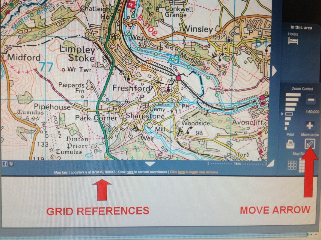
The streetmap website allows you to place an arrow on the location of the sighting and provides the grid reference . BRERC will accept records at four (eg:ST1234), six (eg:ST123456), eight (eg:ST12345678) and ten (eg:ST1234567890) figure grid references. The streetmap website provides grid references in 6 numbers and so it covers the requirments.
See photo of the streetmap web site (below) which indicates the location of the grid reference on the screen.The 'Move arrow' button is also highlighted.(It is necessary to move the arrow to the place of the sighting such that the correct grid references will come up).
There is also an Android app called GPS Test that gives you a UK Grid Reference wherever you are.
Common failures in recording and the easy solutions
- INADEQUATE LOCATION DETAILS ..people send in e mails and "say they found this blackbird in their garden".WHERE IS THE GARDEN? GRID REFERENCE?
- WRONG NAME FOR SPECIES .... people send in records with your their names for things e.g. ‘Small brown moth’. Not adequate name – needs to the right name – check the BRERC taxon and species lists (See http://www.brerc.org.uk/i-maps/index3.html) BRERC always use these ‘preferred’ names or ‘scientific’ names
Or check the National biodiversty network for the ‘preferred’ name
..or the Natural History Museum website
- Have not explained why, how, they have seen a really, really rare thing.
If you do not know what it is send photo on the ispot website www.ispot website and people will tell you.
Record them In Freshford
Record them In Limpley Stoke
It's easy and fun and you are adding vital records to a national database. Look out for sightings on your walks or in your garden.
See below for our 'recording beginers guide'.
How the data is used
The data you send will be analysed by a team of 25 passionate, yet calmly focused,
volunteers will pour over your nformation to ensure that it is correctly logged. ALL species are important both common and rare. If you record a rare species you will help identify those interventions required to preserve them. The local 'Biodiversity Action Plan' which is produced by B&NES, and WILTs is for this very purpose. it is also linked from the FLEWG website from our 'species' page. If you record the more common species you will help identify national trends for that species. Programmes can thereby be put inplace to halt loss of vital habitat, or help cars to avoid flatlining our hedgehog population.Scientists love the data. It is the pallet they work from. Our national records also get integrated into global statistics.
Interactive maps available on the BRERC website (covers both our parishes) show numbers of particular species per km square. This facility tells us that for Limpley Stoke and Freshford there has only ever been a total of 2000 wildlife records submitted. If iyou can help us rectify this by submitting at least one hundred records single handed then please let us at FLEWG know and we will consider you for a certificate of merit and a bottle guaranteed to help you 'go wild' with joy. Please contact us via the
website to let us know when you have got there.
Recording beginers guide:
Any individual resident can report wildlife data which will then be added to formal maps and records for our area - see WSBRC ( Wilts ) and BRERC ( covers North Somerset ) below. They provide record forms that can be filled in on line.
To submit a record you will need a map reference.
The streetmap website allows you to place an arrow on the location of the sighting and provides the grid reference . BRERC will accept records at four (eg:ST1234), six (eg:ST123456), eight (eg:ST12345678) and ten (eg:ST1234567890) figure grid references. The streetmap website provides grid references in 6 numbers and so it covers the requirments.
See photo of the streetmap web site (below) which indicates the location of the grid reference on the screen.The 'Move arrow' button is also highlighted.(It is necessary to move the arrow to the place of the sighting such that the correct grid references will come up).
There is also an Android app called GPS Test that gives you a UK Grid Reference wherever you are.
Common failures in recording and the easy solutions
- INADEQUATE LOCATION DETAILS ..people send in e mails and "say they found this blackbird in their garden".WHERE IS THE GARDEN? GRID REFERENCE?
- WRONG NAME FOR SPECIES .... people send in records with your their names for things e.g. ‘Small brown moth’. Not adequate name – needs to the right name – check the BRERC taxon and species lists (See http://www.brerc.org.uk/i-maps/index3.html) BRERC always use these ‘preferred’ names or ‘scientific’ names
Or check the National biodiversty network for the ‘preferred’ name
..or the Natural History Museum website
- Have not explained why, how, they have seen a really, really rare thing.
If you do not know what it is send photo on the ispot website www.ispot website and people will tell you.
The B&NES environment team have prepared a Green Infrastructure Strategy.
This aims to capture data about people places and resources and this will be completed by the end of 2012. Our proposed work at Parish level in both Freshford and Limpley Stoke will be achieved in synergy with this pioneering work and would hopefully extend through the coming years. The aim is to allow us to more effectively protect, plan, and control from a parish perspective. We can as a result better protect and utilise what we have with enhanced sensitivity to the complex ecosystem that surrounds us.
This aims to capture data about people places and resources and this will be completed by the end of 2012. Our proposed work at Parish level in both Freshford and Limpley Stoke will be achieved in synergy with this pioneering work and would hopefully extend through the coming years. The aim is to allow us to more effectively protect, plan, and control from a parish perspective. We can as a result better protect and utilise what we have with enhanced sensitivity to the complex ecosystem that surrounds us.
An approved method of recording habitat
The DEFRA Handbook is an approved way of recording the types of habitat in our landscape. It is used in compilation of maps used by the countries Record Centres.
The DEFRA Handbook is an approved way of recording the types of habitat in our landscape. It is used in compilation of maps used by the countries Record Centres.
DEFRA Magic Site
This is an online interactive map that will allow you to search for environmental designations (i.e. protected sites such as Nature Reserves, Sites of Special Scientific Interest) and the interactive tools can be used to find further information on the sites and reasons for designation.
The National Biodiversity Network ( NBN )
This gateway allows you to download biodiversity data (species records) for a 10km area. This is a good first step in obtaining species data.
This gateway allows you to download biodiversity data (species records) for a 10km area. This is a good first step in obtaining species data.
The Wiltshire & Swindon Biological Records Centre (WSBRC)
- covers Limpley Stoke
The WSBRC provide a standard data enquiry service that will provide information on priority habitats, County Wildlife Sites, protected and notable species in your area The website also has details of a mapping toolkit and standard biodiversity recording methods, links to Wilthsire wildlife groups including for Fungus, badgers, Botanical, butterflies, geology, mamals, ornithological.See link button below.
Individual community members can file reports which can help build a map of our local area for Limpley Stoke in Wiltshire. This helps build maps which are used as evidence of local wildlife when formal requests are required to WSBRC in considering local development etc. ( Freshford is covered by BRERC - see below )
Bristol Regional Environmental Records Centre (BRERC)
- covers Freshford
BRERC is the central repository for biodiversity and geodiversity data for the ’West of England’ area: the same area as the former county of Avon and it covers Freshford but not Limpley Stoke. You can submit wildlife reports and this helps build maps which are used as evidence of local wildlife when formal requests are required to BRERC in considering local development etc.
Biodiversity South West
This group was formed in 1994 (under its original name of the South West Biodiversity Partnership).
Their vision is "to have landscapes and water bodies, coasts and seas, towns and cities where wild species and habitats are part of healthy functioning ecosystems; where we nurture, treasure and enhance our biodiversity, and where biodiversity is a natural consideration of policies and decisions, and in society as a whole".
Their partnership includes representatives from Government, local authorities, statutory agencies, non-government organisations and local record centres.
Natural England
See below for the link to Natural England's interactive mapping website. In the MAPS tab you will discover a choice of maps about nature and their work, including:
- Nature Reserves and Country Parks (including National and Local Nature Reserves)
- Agri-environment Schemes to improve wildlife on farmland
- Sites which are protected because they are special for wildlife or geological features
- Wildlife habitats that are rare or threatened.
Regional and Local designations
Sustaining and improving biodiversity is a key objective at regional and local level. Strategic Nature Areas (SNAs) and Biodiversity Action Plans (BAPs) identify priority habitats and objectives for protection and improvement. Within our Neighbourhood Plan area there are a number of priority habitats;
· Traditional orchard (Within Limpley Stoke – see map for location)
· Ancient & Semi-Natural Woodland (Short Wood / Hayes Wood)
· Ancient replanted (Short Wood)
· Lowland meadows
· Lowland calcareous grassland
Part of SNA 515 Bathampton – Limpley Stoke falls within the plan area. This designation aims to improve habitat networks (woodland is listed as the main primary habitat) and to sustain wildlife within.
Such designations are found on the Natrual England and Biodiversty maps noted above.
Wiltshire Intellegence Network
Holds a State of the Environment Report together with Maps
See this report ( see under Envronment ) and a map ( see under 'Maps' ). The map shows Environmental Designations for Limpley Stoke ( see under Bradford - on - Avon )
GBIF
The Global Biodiversity Information Facility (GBIF) was established by governments in 2001 to encourage free and open access to biodiversity data, via the Internet. Through a global network of countries and organizations, GBIF promotes and facilitates the mobilization, access, discovery and use of information about the occurrence of organisms over time and across the planet.
