Our Local Post Industrial Sites
See the Habitats map on our local wildlife habitats page for sites recorded thus far by the wildlife record centres.
As a group we are currently looking at further potential sites in the following locations in the Freshford and Limpley Stoke area.
(Note : map references are obtained by use of the Streetmap web site - see the link from our Recording page )
378460,159845 The Old Quarry behind the Glebe
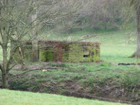
All of the WWII pillboxes on the GHQ defence line
378618,159555 The stone and earth structures forming the banks to Freshford Mill, the two adjacent weirs and the mill “Island” (all of these are in Hinton Charterhouse, but then, so are half the buildings on the Mill development site)
377387,161807 As above for Monkton Combe Mill
379139,160475 Site of small derelict building ? original use
377387,161807 Old Limpley Stoke to Camerton GWR railway at Midford (already marked on map)
Old Limpley Stoke to Camerton GWR railway at Limpley Stoke (already marked on map)
